Geospatial Decision Support Tools to Enhance Conservation Delivery in an Objective-driven Conservation Planning Framework

Webinar Details
When:
Aug 23, 2012 2:00 pm US/Eastern
Length: 01:40 (hh:mm)
Advance Registration NOT required.
View now on-demand.
Reviewed for Continued Content Relevance: 08/2016
Presenter(s):
- Loren W. (Wes) Burger, Ph.D., Professor, College of Forest Resources, Department of Wildlife, Fisheries, and Aquaculture, Mississippi State University
- Mark McConnell, Ph.D. Candidate, Agricultural Ecology Lab, College of Forest Resources, Department of Wildlife, Fisheries, and Aquaculture, Mississippi State University
CEU Credits/Certificate Offered:
- Certificate of Participation
- Conservation Planner (CP) - 1.5 hour Conservation Planning Credit
- The Wildlife Society - Certified Wildlife Biologist®/Professional Development Certificate Program - 1.5 hour TWS Category 1 Credit
Virtual Event Format:
Group Viewing Available:
Participate in this webinar for a description and demonstration of a geospatial decision support tool developed for Mississippi and learn about potential application to other regions.
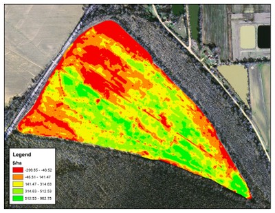
Precise implementation of conservation practices (e.g., CP-33 – Habitat Buffers for Upland Birds) is the foundation of strategic conservation planning and is essential for optimization of environmental and economic benefits. Toward this end, researchers at Mississippi State University developed a regional geospatial decision support tool (Arc GIS tool) to inform the decision-making process at the field-scale. The presenters illustrate the geoprocessing workflow of the tool and demonstrate the conditions under which precision implementation of conservation practices can concomitantly increase whole-field profitability and environmental services for an example farm in Mississippi.
This webinar is sponsored by the USDA NRCS National Wildlife Team located at the Central National Technology Support Center.